Wednesday, October 26, 2011

7.3 Questions

  1. Hydraulic action, Corrasion, Corrosion
  2. Wave refraction is when waves become more dispersed around waves, making it more concentrated around headlands. When the waves become more concentrated the energy also does, making the waves more powerful in the headlands.


  4. Cliffs, rock faces and surfaces
5.Hydraulic action-waves crash against the headlands and trap air in cracks and holes, and is how boreholes are formed.
Corrasion- Waves crash over rock shelves. This action moves rock and other material across the rocks and wears away rock
Corrosion- When waves crash across rocks which have minerals with iron, they wet the rocks and as they dry the salt in the sea water crystallizes and acts on the rock to erode it.
6. The accretion cycle is when big waves and storms wash sand out to sea where it forms sand bars. It then gets washed back to the shore in small quantities by small waves.
7.wind, transportation and erosion
8.Sand is one of the most common things deposited on beaches
9. Wind forms coastal dunes. The wind is blown landwards which gets trapped by low-flying vegetation. The fore dune is sand which has been eroded away. When the vegetation starts dies down, the dunes start to become eroded again and when there has been enough erosion, the vegetation starts to grow again. Then the cycle starts again
10. 

The process is started off by waves coming in on an angle. When they break they loose there energy and the water (swash) goes onto the beach. Then gravity pushes the water back down and back into the ocean where it gets hit by another wave and goes back onto the sand, but further down the beach. The process cycles and that's how sand is transported down the beach. 
11.
This is a picture of the twelve apostles which have been eroded away by wind and water over time to cut them off from the mainland and shape them the way they are.

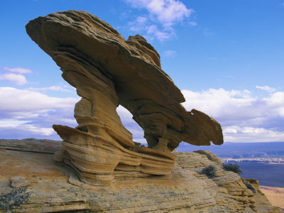
As with the the the twelve apostles, this rock formation has also been caused by years and years of wind chipping at it and water rubbing it into the smooth shape it is today

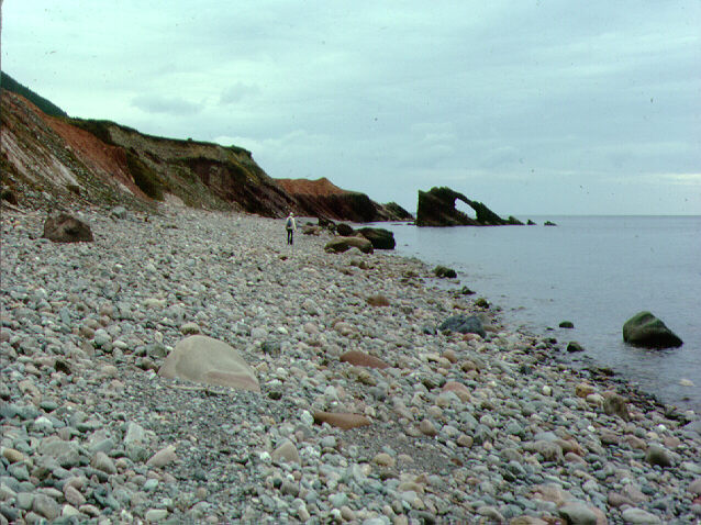
This beach has been caused by coastal deposition as the waves and current of other beaches have picked up sand and other materials such as rocks and shells have dragged them over to this beach were it gets pushed up on shore and forms a beach of its own.
As with the beach above, this one has been formed by waves picking up what mostly looks like sand and dirt and spread it over this deposited beach. It doesn't look as rocky and rough as the one above, but it all depends on what the other beaches have to offer.
12. Fore-dune plays a big part of protecting coastal area's, because the dunes which fore-dune make protects the area's from sand and big waves that, without the dunes, could spill into streets and water supplies.
13. a) On the great ocean road
b)Because they have been around thousands of years and have stayed upright (except one) through storms, waves crashing into their sides and constant erosion.
c)Millions of years ago when the cliffs were underwater, marine creatures would die and sink to the bottom. The marine creatures’ skeletons and shells were of course rich in calcium and as the sediment compacted over the centuries, calciferous clay, or tertiary limestone, was formed.
It is the calcium that acts a cementing product, binding the rock together. Thus, where you have a higher calcium content, or a richer deposit of calcium, you have a stronger variety of rock. This stronger rock has managed to withstand the pounding of the waves and the whipping of the sand-laden winds as the weaker rock has been worn away around it, leaving us today with an amazing array of rock formations.
d)The London bridge was a rock sediment in the shape of an arc that connected the mainland to the offshore rocks collapsed in 1990
e)Yes, I think the landforms collapsing could have been prevented, but that doesn't mean they should be. Those landforms have been there millions of years and would probably pretty unstable by now, and these things were made naturally, why should we interfere with them so they can live longer. I say let nature run its cause and don't interfere in something to make it last longer when it should die on its own course
14. You may be wondering how these landforms were formed. Yes. Well, millions of years ago these rocks were underwater, completely submerged. With them were there sea creature friends, fish, seaweed, sharks. When there friends died, there bones would be left behind. These bones were rich in calcium and that calcium that was left behind helped to stick rocks together. Over time, these once small rock began to grow and grow and became stronger and stronger from all the calcium form the dead fish and animals. Then when the sea water fell dramatically, these rocks were left standing. But they are dying. With all the constant erosion from wind and water, these landforms are loosing strength and will, in time, collapse under the weight and fall.

Tuesday, October 25, 2011

ghost tree


Ghost Tree is located near Monterey Bay, California, just off the 18th hole at Pebble Beach Golf Links. Some say its scarier than Maverick's, heavier than Waimea Bay and among the most dangerous waves in the world.   Wave faces can reach heights of 70 feet, with a tube that stretches as long as a football pitch across a boneyard of black rock.   In 2007 this spot claimed the life of a local surfer, Peter Davi.

These waves are formed out at sea in harsh, stormy conditions and as they reach closer to shore, they hit rock shelves and rise dramatically.


Swell                                                                   Period                                                                  Wind


Swell Chart  Period Chart  Wind Chart

Above are three different views from space all showing different results of the moving water towards the California coastline. The wind and swell are the most important as they show where the wave is getting its main source of power. The wind photo shows us that the wave gains most of its wind power on the coast and just before it crashes.

Monday, October 17, 2011

Surfers waves

Pre-viewing:

  1. Where do ocean waves come from? What gets them started? The oceans waves are made by energy, which comes from the wind way out at sea.
  2. What do you think a surfer should know about waves before they try and ride a wave while surfing?

Question for the Video:


  1. Observe all the waves that you see and describe how they form and break. Use as many words found in the segment for you descriptions. The big waves at maverick when the time is right. it starts out miles in the sea. They are caused by the interaction by the wind and the water. The energy comes from the wind blowing on the sea. The waves are measured by height, frequency and width. When the wind is stronger, the waves are bigger and more powerful. When the energy from the waves hit the bottom of the sea, all the energy is pushed upwards and gives the waves there height. Refraction focuses the energy and pushes it into a wave. The waves break when they hit the sea bed and it sort of trips and pushes the top of the wave over the edge as the base slows down.
  2. Describe how waves are formed, how they originate, and how they are measured? The waves are formed by the energy of the wind. The stronger the wind the bigger the wave.  The waves are measured by height, frequency and width and originate miles out at sea.
  3. What is a maverick wave and what is special about the way it is formed? A maverick wave is a very big wave which holds a lot of energy and once it hits the sea bed, the energy is forced upwards, giving it its massive height.
  4. How is energy stored and transferred during wave? Energy is stored inside the wave, going around in circular motions like a wheel and is transferred by the wind blowing on the wave and moving it, making small ripples and as more and more wind hits it it grows in size
  5. List any kind of advice given by the surfers about how to survive these “big waves.” Be careful, down't over judge the wave and ride the fire before the wrath of god comes down all at once.


Homework:


  1. Design a blog post on your blog of a big wave site from different parts of the world. Be sure to describe the geography and the topography of the ocean floor in these areas and how this helps create these massive waves. check out http://www.extremehorizon.com/surf-shop/big_waves.html for big waves around the world.

Thursday, October 13, 2011

7.2 Questions

  1. The wind is what causes waves. At first it starts with ripples, then those form wavelets and then waves.
  2. The distance the wind travels over the ocean to form waves it known as fetch.
  3. Waves in the open ocean don't break because they are higher up on the ocean seabed, but when they reach the shore they release there energy and break.


  4. Spilling waves are waves that break far from the beaches, meaning that body boarders can body board because they are safe from hitting anyone. Plunging waves are waves that break on the beach creating barrels. And surging waves are waves that just wash up, there are no breaks and its just a gental wave that rolls up the beach, creating erosion.
  5. Wind swells are when the wind hits the water and greats waves that are close to the shore. These waves occur more frequently because they are close to the shore. Ground waves are a lot less frequent and occur way out in the ocean, creating bigger waves.

  6. There are three types of waves that you must look out for, so if you want to find the best ones, you need to know what ones you like. There are spilling waves, which break on the shores, best for body boarding and swimming. Plunging waves, which are the best for surfers because there are barrels. And then there's surging waves which are flat waves which no breaks.

Sorry sir i couldnt get the pictures where i wanted them so there at the top.

Vocab words


Population- There's been an increase of population over the past years and this has been due to a lot of immigration, higher birth rates and lower death rates

Inappropriate development- homes are being demolished for more hotels to be brought in, this means there's more space for people to buy apartments on the coast which causes more population in that area

Tourism and recreational pressure- As people have moved to the coast, the pollution and over population is forming

Tuesday, October 11, 2011

7.1 questions

  1. With 85% of Australia's population living in urban areas just 50 km from the coast, this has caused a numerous amount of geographical issues such as over population and others ranging from various groups.
  2. If its not sustainable then many problems could arise.
  3. population growth
  4. some cities have applied residential caps or a population ceiling in an effort to stop over population
  5. Population- There has been a increase of population over the past decade and this has been a facture of immigration, illegal and legal, higher birth rates and lower death rates
Pollution- with the increase in population there has been more pollution. This is caused by more people throwing out there rubbish without thinking about what they were doing or why were they doing it
Inappropriate development- houses are being demolished for more hotels to be brought in, this means there's more spaces open for people to buy apartments on the coast which causes more over population
Tourism and recreational pressure- With more people coming over to stay on the coast, this adds to the pollution and over population
      6. They help a lot to try and fix the problems that need help being solved. They help the residents of the place they are trying to help.
      7.
          

Wednesday, September 7, 2011

Question 1-11 pg 113

  1. It causes an economic hardship for agricultural population which effects businesses
  2. It caused there neighbours to buy there land which increased there farm area, but as the farms area's increased, the farms in general decreased.
  3. The wool industry collapsed, grazers sold many of there sheep which meant there were lesser jobs on farms, and rising costs in agriculture
  4. if more machinery is being used, then there would be no need for jobs and more people are getting fired.

Tuesday, September 6, 2011

Pg 109 Q 1-7

  1. Its when people migrate from rural areas to urban areas and rural areas are becoming less populated where as urban areas are
  2. Its a small town north of Dubbo, it gets very hot in summer, up to 45 degrees and gets very cold in winter gets to -5 degrees. Its mostly very dry and doesn't get much rain.
  3. Atmosphere: is very hot, humid. Hydrosphere: it's dry, doesn't get much rain. Lithosphere: The town lies on the Castlereagh River which is usually dry, but it flows underground.
  4. They were blocks of land allocated to the retired soldiers. 

  5. 447 people live in the town. 1072 people lived around it
  6. The Community Development Employment Program
  7. b) i) About 1km above Gulargambone. ii) about 5km north iii)10 km
  8. 9a) i) 14818 3118
    ii) 14816 3124
    iii) 14820 3115
    b) i) 62 53
    ii) 63 53
    iii) 61 51
    c) i) 2km
    ii) 5km
    d) i) mainly forest but not many buildings not very dense
    ii) railways, building very dense 

Sunday, September 4, 2011

Mapping questions

Source A-C
What is the predicted population growth rate in 2030?
0.8%
What is the predicted population change in 2030? 60 million
What region of the world is predicted to have the greatest gross increase in percentage between 1800 and 2050?Asia

Source D
How many males and females are there in Ethiopia for the age range 60-64 in the year 2000? 0.7 million
How many males and females are there in Italy for the age range 60-64 in the year 2000?1.4 million
Why do you think that there is such a difference between these two countries? One country (Italy) is more clean, healthy and not as poor as the other country (Ethiopia)

Source E
What is located at GR831979? Dicks hill, price of Wales Rd
What is the highest point at AR7997?
What is the contour interval for the map? 10 m
What physical feature is located at GR820975? Waste water treatment sewer works
Approximately how far is the Laurieton Sporting Complex from Hanleys Point on the Camden Haven Inlet?Around 1 km - 1.5 km
Give the GR for the North Haven Public School.GR830000
What is the highest point at Camden Head? Give the height and GR.GR849987, 75km

Go back to where you came from questions


  • What is your initial reaction to the show?
I think that this show was a good show. It gave people a in site to what refugees and immigrants have to go though to get to Australia and  the problems they faced back in there home country which forced them to leave.

Take this Quiz: http://www.sbs.com.au/thefacttester?question=4


  • What percentage of immigrants are refugees? 1.5%
  • Why does such a small number of people make for such a big deal both politically and in the media? (Give your opinion) It raises the question that if its only 1.5% of refugees come by boat, then why is it such a big political debate and if they do come by boat, it would give other people back in afgan and other countries hope that they could make it as well.

  • Where does Australia rank among countries accepting refugees? 18th
  • To what extent do we have an obligation to help other people suffering in the world? (your opinion)
Personally i think we do a lot more than other countries, but saying that in general i don't think we help out a lot

  • How much extra support do refugees receive in comparison to other Australian citizens?
  • How many Asian nations have signed the UN Refugee Convention? 11
  • Why is it important to note that Malaysia has not signed the UN Refugee Convention? What does this mean for refugees in Malaysia? It means that Malaysia's are stuck in Malaysia and they cant get out of it

Monday, August 22, 2011


  1. What is demography? Demography is the statistical study of human population.
  2. In what year did the Australian population reach 20 million? How quickly is the population growing? 2003, December 4th, in 2009 it was one million in 2 years, so its steadily rising.
  3. How many Aboriginal people are estimated to have lived in Australia before Europeans arrived? 300 000 and one million, immigration = 53%, natural birth = 47%
  4. What the two main ways the population can grow? What percentage of the population growth in 2010 can be attributed to each way? Immigration and natural birth, 133.000 people moved to Australia in 2010.
  5. What is the total fertility rate for 2010? Births/Women 1.78
  6. What was the total fertility rate for Australia in 1935? How does this compare to other years? Why do you think that it compares this way? Births/women 2.1
  7. What is the trend in the fertility rate for Australia since 1950? It goes down on a slope and levels out.
  8. What is the average size of a family in Australia? How does that compare to the US? 2.6 per house in Australia, 2.59 in America

Tuesday, August 16, 2011

Are we a Racist Nation


  1. Who is the author and what is his job title? Graham Innes,  Race Discrimination Commissioner
  2. Who does he work for and what is supposed to do in this job? He works for the Government
  3. What does the author say is often the beginning of a racist comment? Have you every heard anyone use this line to say something racist? If so, what did they say? 'I'm not racist but' and i have heard some one say 'I'm not racist, but Asians can't drive'
  4. What percent of Australians are born overseas or have an overseas parent? 50%
  5. What is a 'monoculture'? That only one culture is accepted in one place
  6. What are some welcome benefits of online technology?  They have connected all the cultures together, sharing stories. 'They also have connected the world's indigenous peoples, as well as ethnic minority groups, in a way they have never been connected before - to share stories, co-ordinate their work, and collectively organise.
  7. What are some unwelcome results of online social media? 'The proliferation of race-hate websites and materials breeds and incites real world hatred'
  8. What makes racism online so dangerous? It spreads from the Internet and into classrooms and out into the open where all the new racist jokes come from.
  9. What will help stop racism online? There are anti-bullying organisations coming out and some f the material is getting removed off the web and most of the complaints have gone down as well
  10. What does the author suggest we need to do to stop racism? We must say no to racism, no more jokes, no more remarks.

Tuesday, June 14, 2011

How our communities have changed

There are many obvious change that can be seen if you just look around. One main change is the look of buildings. All this modern day, slick, glassy buildings never used to be used in the 90's. And another is the fashion of what people were. But there's also the new developments of malls and car parks and all the renovations to schools and homes. And with the population of Australia growing and leaving, more houses need to be built.

Thursday, June 9, 2011

Peer evaluation

Campbell Fisher: Campbell has been a very hard worker throughout the past week, he communicated well with the group and finished his work if not in class, then at home. He always was on time and id say did a very good job.
Nic Kuna: Nic wasn't here at all when me and Campbell was doing the work, he didn't really help out but he did get some information about the natural disaster and if he was here, would have worked well in the group

Tuesday, May 31, 2011

Where im up to

so far I have done a brief description of what El Nino and La Nina is and i have done the La Nina Australia map of the effects of Cyclone Yase

Monday, May 16, 2011

Year 9 Exam Prep

1. How many hectopascal (hPa) is the high over the Eastern side of Australia? 1032
2. What LARGE part of Australia is experiencing rain? Western Australia
3. Give the approximate location of the centre of the high on the east coast? Victoria
4. How would you compare the speed of the wind for Australia to New Zealand?  New Zealands wind speed is a lot faster than Australia since the lines are closer together

5. What month has the warmest temperature? May
6. What hemisphere is this city in? Northern Hemisphere
7. What month has the highest rainfall? July is just higher than August
8. What is the average temperature and rainfall for November? The average temperature is 27.5 and the average rainfall is 100mls
9. What latitude do you think this city is at? Why? 14.5* N, 

Tuesday, May 10, 2011

2.4

1. A flood is water that inundates land which is normally dry.
2. Flash flooding is when  rivers and streams are unable to cope with the sudden volume of water caused by heavy downpour. Urban areas are especially vulnerable due to the drainage systems which can become overloaded, resulting in flooding.
3. The inland rivers generally cover thousands of square kilometres in water lasting weeks, whereas the Coastal River systems tend to be short and fast flowing, generally lasting from a few hours to a few days.
4. Flooding affects farms, when it comes to stock and crops, but it also destroys infrastructures like roads and railway lines.
5. The town of Katherine received 374 millimetres of rain while the surrounding catchment area received between 400 and 500 millimetres over a short period of time (48 hours). The catchment was already saturated from previous weeks rainfall so most of the new rainfall ran off into the river which quickly caused a flood. The reason it was considered worse than the 2006 flood was because the 1998 flood peaked at 20.3 Metres above its usual flow level, where in 2006 it only peaked at 19 Metres.
6.
Economic: The flood would of impacted the Economy in Katherine due to the damage caused by the flooding, which cost a lot of money in repair costs.
Social: The social impact was bad because it caused 500 businesses and 1170 homes to be evacuated and Four people were killed as well as flooding the Whole town.
Environmental: The flooding can drown plants and crops and livestock.
7.
b) The Coastal gradient was a lot smaller than compared to the Inland River Catchment Gradient.
c) The gradient in a Coast area is a lot smaller so the water hasn't got that much land to pass through before it is cleared, compared to the inland river systems which have thousands of kilometres to pass through.
10. I had just moved to the town called Katherine, I decided to buy the local Motel because it seemed to be just about the only place tourists would be able to stay meaning it would be money well spent, if not profitable. Little did I know that it was in one of the worse areas if a flood were to occur. It was almost February of 1998, and one of the worst floods I've ever seen hit. 2 Metres of water came rushing through taking cars with it. As soon as I saw the water I knew the damage would be devastation. We moved to the highest floor in the motel avoiding the water, but we could hear it as it seeped through the doors and open windows flooding the motel below us. We came outside to see people crying at the loss of their possessions and one person actually asking why the floods had taken his son. It was truly one of the worse days that Katherine had seen.

2.5

1. A tropical cyclone is a storm system characterized by a large low-pressure centre and numerous thunderstorms that produce strong winds and heavy rain.
2. They occur anywhere in the tropics.
3. Queensland, Northern Territory and North Western Australia.
4. out of the 10 that form in the Australian region 6 of them cross the coastline.
5. Hurricanes or typhoons.
6. a. tropical    b. moist    c. heat     d. high    e. spiral   f. surface
7. The eye is middle of the cyclone and it is calm and has clear sky.

2.3

1.       1.Hail which is 2 cm in diameter, winds of 90 kms, flash flooding and tornadoes
2.       2.The potential to destroy houses and property
3.       3.When humid air gets pushed upward into the atmosphere by converging surface winds, the air rises, moisture condenses and releases heat energy called latent heat which causes buoyment allowing it to rise further into the atmosphere and freezes which causes crystals to drop and create hail.
4.      4. Its heat energy and its one of the steps that create hail
5.       5.Up in the higher atmosphere where its colder and water particles can freeze
6.       6.It’s more likely for a tornado to form in the ocean or on a river since its colder
7.       7.The bureau of meteorology by the study of synoptic charts and weather conditions
8.       8.Because people can never judge how big or wild it will be and there’s no real evidence that it will strike were and when its predicted
9.       9.A) at 1:10 pm b) Maitland, Raymond Terrance and Newcastle, Lemon Tree Passage and Nelson’s Bay c) 2:10 pm  d) to turn off your laptops, to get away from the windows, to move all loose objects and hide under the desks until storm passes or you are instructed to leave.

Tuesday, May 3, 2011

Weather journals

Today is the 4th of may and we went outside to see what the weather was like. It was cool and crisp, with a nice, slight cool breeze on the early autumns morning, with a slight slight chance of showers because the clouds in the sky look a little grey (altos stratus) even though there aren't that many, I wouldn't get worried about rain today but i would be a little weary of the weather.

Monday, May 2, 2011

Deadly Storms in the US

  • Deadly storms had hit around the south east of the US.
  • 318 people died in deadly storms
  • 33 in Mississippi
  • 228 in Alabama
  • Tennessee 17
  • A high risk storm it was called
  • A rare high risk threat area has been issued for far northwestern Georgia which means a major severe weather outbreak is anticipated with a concentration of tornadoes and straight-line wind gusts of 80 mph
  • Being called supercell thunder storm, the strongest kind of stroms.
  • The Storm Prediction Center has issued 82 high risk areas since 1984. Today is the 3rd one this April…and this year.

Sunday, May 1, 2011

2.2 questions

  1. A disturbance in the earths crust
  2. movement of a mass of rock or the earths crust, eathquakes and rain
  3. Construction of roads and rails on hillsides
  4. They are mesured in magnitude and richterscale 
  5. Intra plate tension
  6. On average every 15 months
  7. Killing 13 people and injuring 120 and 35 000 damaged
  8. Landslides are movements on the earths crust while eathquakes are movements under the earhen earthquake under the ths crust
  9. A really really really big/ strong wave
  10. Earthquake, movement of the oceans bottom, landslide under the ocean
  11. Normal water level, then earthquake under the ocean, waves move deeper into the ocean more rapidly and then reaching 800 kph tsunami hits the beach.
  12. Shake, drop and roar
  13. An 9.3 earthquake
  14. 23 stations and it took 20 minutes to get picked up
  15. As it enters shallow water it is pushed up slowing it down but increasing its height
  16. They responded by making the tsunami warning system in the indian ocean
  17. He is a wollongong university geoscience proffessor and warned that new zealands alpine fault line could cause a tsunami to hit NSW
  18. a) 10*N, 95*E     b) i) Roughly 3 hours    ii) 7 hours     iii)  5 hours     iv) 10 hours

  19. A yellow sign which has a tsunami on it and bellow that it would say beware of tsunami and high waves, listed for roaring and strong currents.

Tuesday, April 26, 2011

2.1 Natural Hazards

  1. When the weather becomes strong that it causes damage e.g drought
  2. A natural disaster impacts on a community where as a natural hazard strikes some where and doesn't effect a community
  3. Those related to weather, and those related to the movements of the earth's crust
  4. Weather- Cyclone, heatwave, drought, flood, storms, tornadoes. Movement of the earth's crust- landslides, earth tremors, earthquakes.
  5. Because more people are effected from it
  6. Economic impacts, Environmental impacts
  7. Social- loss of life, stress on families, Economic- damage to industry, Environmental- Destruction on nature and human environment
  8. So we can be prepared for what is going to happen
  9. So they can predict where a natural hazard is more likely to occur
  10. a)tropical cyclone, bushfire, flood.b) Heat waves
  11. a)they could warn families about how high the hazard rate is and they could prepare just in case3.
b) Each state has a different rates and could enforce rules for this reason
c) medical centres and hospitals could be set up out of of the disaster areas but close enough to help
d) They can insure peoples houses and things in case of a hazard

Thursday, March 17, 2011

  1. Coal, Oil and Gas
  2. Solar, Water and Wind
  3. Becuase of the climate change
  4. Australia, China, US and India
  5. 76 Billion tons

  6. It will be 800 meters long and will earn 1500 more energy than a solar polared roof
  7. Wind blows the turbin around which causes friction and creates energy


9.

Tuesday, March 15, 2011

Questions 1.10

  1. Resources are materials that can be used by humans.
  2. Renewable resources are resources that can never run out such as sun light. Non-renewable resources are things that can  run out such as coal.
  3. By over exploitation.
  4. Soil can give us many things and is essential because with out soil we can't plant crops and foods that we need to live.
  5. The branch of forestry dealing with the development of rain forests
  6. 1.7 million square killometers
  7. Very valuable it is over $2 billion dollars a year
  8. The AFM authority
  9. Iron, lead, zinc, uranium and a few more
  10. By improved prospecting
  11. Australia has a huge amount of forest that spans of 162.7 million hectares. Australia has 74 000 hectares a year which means we have a lot of plantation ready for the future. 
  12. It is so valuable because Uranium is so dangeroues that some countries want them to destroy cities in wars and such.
  13. World heritage sites are valuable resources because they attract tourists so we get more money.
  14. I think it impacts a lot because it releases smoke and chemicals into the landscape and air killing plantation any where near the mining plantation
  15.  Australia is practically surronded by fishing grounds.
  16. a)There sprend out over the middle of australia theres a clump of uranium reserves in north australia
b) Radium hill
c)Ranger
17.
18. i)approx 395 million
ii)Approx 240 million
iii)Approx 550 million
b) 382 million
c) it rose in value in time

Japan eathwuake 2011 questions

1. Kessennnuma, Myagei
2. 9.0
3. One of the most affected areas in japan was Sendai. The Earthquake with the addition of the Tsunami destroyed many lives and destroyed many houses and buildings.
4. A man made disaster that happened when the earthquake hit was that a nukelier plant was partly blown up.

Sunday, March 6, 2011

1.7 Geog Questions

1.       Australia has been separated from the rest of the world so the animals and plants have grown separately which means Australia has different plants and animals
2.       Because the animals have survived due to the stability of the country.
3.       Found only in
4.       82%
5.       Great barrier reef, tropical rainforest in Queensland and South Australia
6.       In tropical rainforests
7.       Marsupials night time only critters so they only go out at night, Bats are marsupials
8.       Mammals that lay eggs, Echidna
9.        Wallabies are generally smaller than kangaroos
10.   The duck billed platypus is one of the unusual animals In Australia. They are found in lakes and are shy animals. They spend 12 a day in the water swimming searching for food or things for building there burrow.
  1. A fern is any one of a group of about 12,000 species of plants. Unlike mosses, they have xylem and phloem (making them vascular plants). They have stems, leaves, and roots like other vascular plants. Ferns do not have either seeds or flowers (they reproduce via spores)